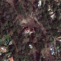
 Copyright 2018 DigitalGlobe(MONTECITO, Calif.) — Satellite images released by DigitalGlobe on Friday show areas of Montecito, California, before and after the area was hit by heavy rainfall and deadly mudslides.
The unincorporated area of Montecito was put under a mandatory evacuation order on Thursday and more than 500 homes in the county were damaged or destroyed, according to numbers released by the Santa Barbara County Fire Department.
Seventeen people have died in the mudslides and many more are feared missing.
 Copyright 2018 DigitalGlobe
Click here to see more of the satellite images.
Copyright © 2018, ABC Radio. All rights reserved.