 ABC News(NEW YORK) — The 110 reports of severe weather on Monday, mostly from Kansas, included three tornadoes, baseball-sized hail and straight-line winds of 80 mph.
Torrential rain has caused flash flooding in Kansas, where the town of Chanute saw almost 4.7 inches of rain, a daily record for May 6, requiring several homes be evacuated.
Radar reports show organized thunderstorms and heavy rain moving across Kansas and Missouri early Tuesday, but the severity of those storms should wind down later in the morning.
The next storm, however, is organizing over the Rockies and headed for the Plains later Tuesday.
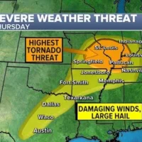
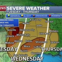
Through Thursday, more than 40 million Americans are at risk of seeing severe weather from Texas to Missouri.
Oklahoma and Texas are especially vulnerable Tuesday, with several regions at varying degrees of risk for destructive winds, large hail or tornadoes.
The storm will begin to congeal, with a long line of powerful storms hitting Oklahoma City and Dallas Wednesday morning. Ultimately, more severe storms will be possible from east Texas through Missouri. From east Texas into western Lousiana, temperatures may warm enough on Wednesday to increase the risk of tornadoes spawning.
Weather risks on Thursday should slide a little south and east, with numerous thunderstorms developing from Louisiana to Tennessee.
Locally, certain areas this week could see 6 to 8 inches of rain, leading to more flash flooding and rapid river rises — including in some of the region’s more urban areas.
Additionally, widespread rainfall totals from this large storm system in the 2- to 4-inch range are expected along other parts of the Mississippi River Valley, as well as from Oklahoma up to Wisconsin, which could aggravate existing flood conditions.
Copyright © 2019, ABC Radio. All rights reserved.