 ABC News(NEW YORK) — Hurricane Dorian began inching northwestward over the Bahamas Tuesday morning after hovering there for hours, and forecasters say the now-Category 3 storm will later move “dangerously close” to Florida’s east coast.
The monstrous storm has been blamed for the deaths of at least five people on the Abaco Islands in the northern Bahamas, where it touched down Sunday afternoon as a Category 5, the strongest Atlantic hurricane landfall on record. Dorian then came to a grinding halt over Grand Bahama, the northernmost island of the Bahamas archipelago where it has remained at a virtual standstill since Monday morning.
An official with the U.S. Department of State told ABC News on Tuesday morning that Bahamas Foreign Minister Darren Henfield reports “nearly everything is gone” in Marsh Harbour, a town in the Abaco Islands, and the Leonard M. Thompson International Airport there is completely submerged.
Meanwhile, there are reports of heavy flooding in Freeport, the main city on Grand Bahama, where Grand Bahama International Airport is inundated with water as is the city’s one-story hospital, and the main highway has turned into a river, leaving some people trapped, according to the U.S. State Department official.
Iram Dewitt Lewis, the parliamentary secretary in the Bahamas Ministry of Public Works, told ABC News by telephone from Freeport that the rain and winds were letting up Tuesday morning, but the power was still out and communications were down.
“Never seen anything like this in my life,” Lewis said in the interview, which aired on Good Morning America.
Residents of the Bahamas who have chosen to shelter in place for previous major hurricanes and decided to ride out Dorian said they endured hours of abject uncertainty and fear on Sunday night.
“I think when the eye wall hit, we had 200-plus mile per hour winds that ripped everybody’s roofs and destroyed everybody’s structure and houses,” Bruce Sawyer, a resident of the hard-hit Abaco Islands, said in an interview Monday on GMA.
“Probably one of the most terrifying things that ever happened,” Sawyer added. “The windows were caving. The doors were caving in. I honestly thought that our roof was going to be ripped off as well.”
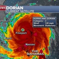
Hurricane Dorian has since been downgraded to a Category 3, with maximum sustained winds near 120 miles per hour. But the storm has grown in size over the past 48 hours while remaining almost stationary. Tropical storm force winds have expanded away from the center and now stretch as far as 160 miles outside the eye of the storm. As a result, parts of Florida’s Palm Beach County experienced 60 mph wind gusts on Tuesday morning.
“Dorian has been stuck in the northern Bahamas because the high pressure that was steering it has collapsed,” ABC News senior meteorologist Max Golembo said. “So its been sitting in the same place for days, waiting to be picked up by upper level winds.”
In its latest updated advisory, the National Hurricane Center urged residents on Grand Bahama island to stay in shelter as they continue to experience Dorian’s eye wall, which surrounds the storm’s eye and packs the most damaging winds and intense rainfall. Residents there could see wind gusts of up to 150 mph, extreme flooding from up to 30 inches of rain and a storm surge of 10 to 15 feet above normal tide levels with even higher destructive waves throughout Tuesday, according to the National Hurricane Center.
The latest forecast models show Hurricane Dorian beginning to move north later Tuesday morning and afternoon. The storm will then come “dangerously close” to Florida’s east coast Tuesday night through Wednesday evening, get very near the Georgia and South Carolina shorelines Wednesday night into Thursday and then move near or over North Carolina’s coast Thursday night, according to the National Hurricane Center.
“The projected path takes the core of the strongest winds, rain and waves just east of Florida,” Golembo said. “Any movement to the west will bring the worst of the storm closer or even possibly on shore to Florida.”
Dorian is expected to gradually weaken down to a Category 2 hurricane as it nears Wilmington, North Carolina, and could potentially make landfall Thursday night on the Outer Banks, barrier islands off the coast of the Tar Heel State. On this current forecast track, the worst of the storm will stay out to sea, but gusty winds and storm surge will remain a threat to the southeastern U.S. coast. The heaviest rainfall is expected to hit the coastal Carolinas, where up to 15 inches of rain is possible in isolated locations.
Hurricane warnings stretch from near West Palm Beach, Florida to just south of Jacksonville, Florida, where hurricane watches then extend to just north of Charleston.
Mandatory and voluntary evacuation orders have been issued for dozens of coastal communities from South Florida to the Carolinas. Meanwhile, thousands of flights have been cancelled and some airports have been shuttered as the hurricane approaches the United States.
Pete Gaynor, acting administrator of the Federal Emergency Management Agency, told ABC News that his greatest concern was flooding and storm surge, which he said are responsible for 90 percent of all deaths from natural disasters.
“What we really want to get across this morning is that time is running out to make preparations.” Gaynor said in an interview Monday on GMA.
“The unpredictability, the uncertainty of where Dorian will go is something that we’re all anxious to find out,” he added, “but you have to be prepared for any scenario.”
Copyright © 2019, ABC Radio. All rights reserved