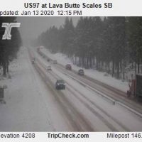
URGENT - WINTER WEATHER MESSAGE
National Weather Service Pendleton OR
957 AM PST Mon Jan 13 2020

.Another storm system will swing through the region and bring
multiple rounds of snow across Oregon and southern Washington this
afternoon through tomorrow.

ORZ041-044-507-508-510-511-WAZ024-140300-
/O.CON.KPDT.WW.Y.0004.200113T2000Z-200115T0000Z/
East Columbia River Gorge-Lower Columbia Basin of Oregon-
Foothills of the Northern Blue Mountains of Oregon-
Foothills of the Southern Blue Mountains of Oregon-
North Central Oregon-Central Oregon-
Eastern Columbia River Gorge of Washington-
Including the cities of Arlington, The Dalles, Boardman,
Hermiston, Ione, Pendleton, Pilot Rock, Heppner, Condon, Fossil,
Dufur, Maupin, Moro, Bend, Madras, Prineville, Redmond,
and White Salmon
957 AM PST Mon Jan 13 2020

...WINTER WEATHER ADVISORY REMAINS IN EFFECT UNTIL 4 PM PST
TUESDAY...

* WHAT...Snow expected. Total snow accumulations of 2 to 5
  inches.

* WHERE...Portions of central Washington and central, north
  central and northeast Oregon.

* WHEN...Until 4 PM PST Tuesday.

* IMPACTS...Plan on slippery road conditions. The hazardous
  conditions could impact the morning or evening commute.

PRECAUTIONARY/PREPAREDNESS ACTIONS...

Slow down and use caution while traveling.

The latest road conditions for the state you are calling from can
be obtained by calling 5 1 1.