 ABC NewsBy MAX GOLEMBO, ABC News
(NEW YORK) — There is a rare Hurricane Warning for parts of Hawaii Monday morning as Hurricane Douglas passes dangerously close to the state, bringing gusty winds, flooding rain and life threatening surf.
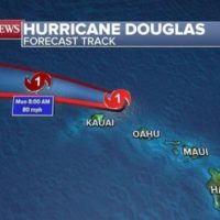
Right now, Douglas is about 50 miles northeast of Lihue, Hawaii, and about 100 miles northwest of Honolulu.
Douglas has winds Monday morning of 90 mph making it a high end Category 1 Hurricane.
This is a pretty rare occasion to have a full blown hurricane pass so close to Hawaii.
Only two hurricanes in recorded history have made landfall in Hawaii, Hurricane Iniki in 1992 and Hurricane Dot in 1959.
There were other hurricanes that tried to make a run at the Hawaiian islands such as Hurricane Lane in 2018 and Hurricane Lester in 2016 but they never made it as close as Douglas is now with winds of 90 mph.
The forecast track takes the eye of Douglas just north of Kauai in the next six to 12 hours, bringing gusty winds, flooding rain and life threatening surf with some minor damage possible on the island.
Meanwhile, Hanna is dissipating over Mexico Monday morning but it also managed to make history on Saturday when it made landfall as a Category 1 hurricane at 6 p.m. EST on Saturday with winds of 90 mph on Padre Island National Seashore, which is about 50 miles south of Corpus Christi.
Hanna brought wind gusts of up to 68 mph to Corpus Christi and 81 mph wind gusts to Baffin Bay Padre Island.
Up to five inches of rain fell in Corpus Christi and the storm surge was in excess of five feet.
Widespread flash flooding and coastal flooding was also reported in the city.
Additionally, Hanna was the earliest “H” storm ever recorded in U.S. history and only the second fourth-named storm to make landfall in the U.S. so early in the season.
The only other fourth-named storm to make landfall in the U.S. this early was a Category 4 hurricane in 1886.
Now, attention turns to the East where a new tropical system is developing in the Atlantic and, in the next 24 hours, it could become a tropical depression or a tropical storm. If it becomes a tropical storm it would be Isaias.
It is still too early to tell where exactly this system will go and how strong it will get, but people living in the northwest Caribbean islands including Puerto Rico should be paying attention to the forecast.
Elsewhere, another heat wave is expected in the Northeast and the East Coast this week.
A Heat Advisory has been issued from North Carolina to Maine where temperatures could get close to 100 degrees.
Copyright © 2020, ABC Audio. All rights reserved.