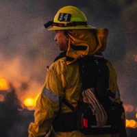
Ochoco National Forest Plans Prescribed Burn North of Big Summit Prairie
Prineville, Ore. – If conditions remain favorable, firefighters are planning a 2,560 acre prescribed burn north of Big Summit Prairie on the Ochoco National Forest. Ignitions will begin tomorrow and are expected to take approximately five days to complete.
Crews will be lighting the prescribed burn in HEJ burn blocks 1-7, with low intensity fire reducing hazardous fuels and improving the condition of riparian vegetation along stream and riverbanks. Ignitions are planned for 10:00 a.m. Friday and firefighters are planning to burn 1-2 blocks a day for 500-700 acres until ignitions are complete. Firefighters from each division of the Central Oregon Fire Management Service (Ochoco and Deschutes National Forest and Prineville District Bureau of Land Management) in addition to Crook County Fire and Rescue, Sunriver Fire Department and the Alfalfa Fire District will be working together to successfully implement the burn and hold fire along fire lines and roads.
When ignitions are complete, firefighters will mop-up and patrol the perimeter for the next several weeks. No closures are anticipated with this operation. However, if smoke drifts on to roads, motorists should slow down, turn on headlights, and proceed with care.
The public’s health is important to the Forest Service. While significant preventive measures are taken, many factors influence a person’s susceptibility to smoke, including severity and duration of smoke exposure and a person’s health. If individuals feel impacted by smoke, they should avoid outdoor physical exertion and remain indoors. If people experience serious health impacts from the smoke, they should contact their doctor. For more information about smoke and health, visit the Oregon Health Authority recommendations through this link: http://www.oregon.gov/oha/PH/Preparedness/Prepare/Pages/PrepareForWildfire.aspx#health
Fuels specialists will follow policies outlined in the Oregon Department of Forestry smoke management plan, which governs smoke from prescribed fires (including pile burning), and attempts to minimize impacts to visibility and public health.
Keep up with prescribed burns in Central Oregon by visiting: http://www.centraloregonfire.org
For more information, visit the Ochoco website at www.fs.usda.gov/ochoco and follow us on twitter @CentralORFire.
Deschutes National Forest Officials Remove Lionshead Fire Closure on Sisters Ranger District
Closure order rescinded after area receives heavy rainfall decreasing fire activity
Sisters, Ore.- Deschutes National Forest officials have rescinded the remaining portion of the Lionshead Fire Closure reopening access to the entirety of the Sisters Ranger District’s portion of the Mt. Jefferson Wilderness and access along Forest Service Road 12. The Lionshead Fire received heavy amounts of precipitation limiting decreasing fire behavior and activity.
Visitors should use caution when traveling in the Metolius Basin as firefighting resources continue to conduct work in the area.
Deschutes National Forest Officials Remove Lionshead Fire Closure on Sisters Ranger District
REDMOND, Ore. – After precipitation on Wednesday, fuels began slowly drying out but are not expected to reach critical levels. The next weather system is forecasted to impact Central Oregon this weekend, returning to seasonal conditions.
Suppression repair has been completed in the southeastern portion of the fire perimeter near the Metolius River. Additionally, repair work is scheduled for completion today along the southern portion of the fire. Crews are ensuring that fire is no longer active or burning along the fire perimeter. Firefighters continue completing additional tasks for the local jurisdictional units.
On Thursday, fire managers plan to continue hazard tree removal and road grading activities while patrolling and monitoring the perimeter of the fire for hot spots. Crews do not expect the fire activity to increase but will be available in case smoke increases around the perimeter of the fire.
Northwest Incident Management Team 13 is planning to transition management of the fire to local unit incident management organizations on Friday. “Firefighters continue to work hard to be stewards of the land,” said Incident Commander Brian Gales. Incoming fire management teams will continue the suppression repair, patrolling and monitoring work began many weeks ago.
Weather: Precipitation has ended for the week, bringing a stretch of warmer and drier weather. Officials do not expect fire activity to increase despite the warmer and drier weather. Shorter days greatly reduce the likelihood of increased fire activity, even with forecasted warmer weather. Cooler and drier weather is expected over the weekend with highs in the 60s.
Safety: Unpaved roads are muddy, particularly on the west side of the Cascade Crest. Rock falls and falling trees create potential hazards around the fire footprint. Use caution when traveling on newly opened roads, as unmarked hazards may exist.
Lionshead Fire
Pacific Northwest IMT #13
Public Information Phone: 971-277-5075
Media Inquiries: 541-904-0542
Incident E-mail: 2020.lionshead@firenet.gov
Incident Website: https://inciweb.nwcg.gov/incident/7049
YouTube: https://www.youtube.com/channel/UCHSR6_yJRQkHyGjvvqX99gw
Facebook: www.facebook.com/LionsheadFire
Archie Creek & Thielsen
NORTHWEST INCIDENT MANAGEMENT TEAM 12
Incident Commander: Bob Shindelar
October 15, 2020
The Archie Creek Fire is east of Roseburg in the North Umpqua corridor on state,
private, and federal land. The Thielsen Fire is located five miles north of Crater
Lake near Diamond Lake on National Forest lands. The warming and drying trend
will continue today and extend through the weekend. Winds will be out of the
north-northeast at 8-10 mph in the valleys, with northeast winds 10-15 mph on
the ridges. Temperatures today will be in the low to mid 60s.
Yesterday’s Operations:
Archie Creek – Crews continued to identify and retrieve remaining equipment no
longer needed on the fire lines. Firefighters patrolled and monitored around the
fire perimeter. Suppression repair work continued to minimize erosion and protect
resources. Fire crews continued removal of hazard trees along roads. The BAER
team continued their post-wildfire assessments to determine appropriate
mitigation actions on National Forest lands.
Thielsen – Fire crews continued patrol and suppression repair work along
containment lines. In the North Diamond Division, firefighters improved ingress
and egress to Highway 138 and removed hazard trees along FS 005 road.
Additionally, firefighters removed debris in the southern area and chipped
vegetation debris in the northern area.
Today’s Operations:
Archie Creek – Firefighters will patrol and monitor around the fire today.
Firefighters will continue suppression repair work on the containment lines to
restore natural drainage on the landscape. Resource Advisors from the Forest
Service are working closely with firefighters during implementation of suppression
repairs to minimize erosion and protect resources. Fire crews are retrieving any
remaining equipment left along the fire lines. Firefighters are continuing their work
removing hazard trees and snags along transportation corridors. The BAER team
continues to assess post-wildfire environmental conditions and determine
appropriate actions to mitigate the effects of fire suppression on National Forest
lands.
Thielsen – Fire crews will be patrolling and focusing on suppression repair work
along containment lines. In the North Diamond Division, work on improving
ingress and egress to Highway 138 will continue. Firefighters will identify and
remove hazard trees along FS 005 road. Firefighters will continue debris removal
in the southern area and chipping in the northern area.
Safety Message & Help for Fire Victims:
Archie Creek: 131,542 acres
CONTAINMENT: 95%
PERSONNEL: 221
Thielsen: 9,975 acres
COMPLETION: 75%
PERSONNEL: 83
CAUSE: under investigation
for both fires
MILES OF FIRELINE REPAIRED:
94.3 (across both fires)
MILES OF REPAIRED ROADS:
51.7 (across both fires)
RESOURCES:
Archie Creek Thielsen
Hand Crews 2 0
Engines 2 2
Dozers 1 1
Water Tenders 0 3
FIRE INFORMATION:
(971) 334-7674
2020.archiecreek@firenet.gov
INCIWEB:
https://inciweb.nwcg.gov/incident/7176/
FACEBOOK:
ThielsenFireInfo/
Please stay out of fire closure areas for your safety and that of the firefighters. Sawyers are felling hazard trees along roadway
corridors, and there is increased traffic as firefighters reposition heavy equipment on narrow roads. Visit the Oregon
Department of Environmental Quality at http://www.oregon.gov/deq for Air Quality information. Be cautious driving in low
visibility conditions. Disaster aid, and organizations helping victims of the Archie Creek Fire, can be found at
https://inciweb.nwcg.gov/incident/article/7176/57029/.
Closures, Restrictions & Evacuations:
• Due to cooler temperatures and rain this week, Public Use Restrictions have been removed on Umpqua
National Forest and Roseburg District BLM lands. Fire season remains in effect, however campfires in undeveloped
sites and outside of approved fire rings will be allowed on Roseburg BLM and U.S. Forest Service lands. Members of
the public are reminded to never leave a campfire burning unattended and to make sure the campfire is completely
extinguished before leaving the area.
• Roads – Highway 138E is open, but delays should be expected. The route to Miller Lake via FS Road 9772 remains
closed from the intersection with Hwy. 97 to the intersection with FS Road 110 due to firefighter traffic. Drivers are
being directed to take FS Road 9774 to connect with FS Road 110 as an alternate route. See www.tripcheck.com for
updates on highway closures.
• Bureau of Land Management – All BLM-managed lands in the Swiftwater Resource Area east of the Range 3 and 4
boundary line and north of Little River Road are closed. This includes portions of Rock Creek Road and all BLM
recreation and day use sites within the closure boundary, including Rock Creek, Lone Pine, Millpond, Scaredman and
Susan Creek campgrounds. Cavitt Creek Falls Campground is closed for the season. For more information, see
https://inciweb.nwcg.gov/incident/article/7176/57115/
• Umpqua National Forest – Sections of the North Umpqua and Diamond Lake Districts remain under a fire closure
order. Umpqua Hot Springs, fire lookouts, cabins and group picnic sites remain closed. Diamond Lake Resort and
Diamond Lake are now open for public recreation, but Diamond Lake Campground is closed for the rest of the year.
North Umpqua District closure: https://inciweb.nwcg.gov/incident/article/7176/57090/ and Diamond Lake District
closure: https://inciweb.nwcg.gov/incident/article/7195/57398/. More information on Forest Service closures is available
at: https://www.fs.usda.gov/alerts/umpqua/alerts-notices. The Umpqua National Forest is currently at Industrial Fire
Precaution Level I. The fire danger is Moderate.
• Temporary Flight Restriction – No temporary flight restrictions are in effect for the Archie Creek or Thielsen Fires.
• Evacuations – No evacuations remain in place.