 ABC NewsBy DANIEL MANZO and DAN PECK, ABC News
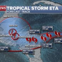
(NEW YORK) — Tropical Storm Eta formed overnight Saturday, strengthened throughout Sunday and is now moving toward Nicaragua, according to the latest forecast Sunday evening.
The storm’s center is about 200 miles east of the Nicaraguan coast. It is generating sustained winds of up to 70 mph, forecasters said, and is moving west at 13 mph.
Eta will continue to strengthen over the next 36 hours and will likely reach hurricane strength Sunday night.
Hurricane warnings have been issued for parts of Honduras and Nicaragua.
Eta is the 28th named storm of the 2020 Atlantic hurricane season meaning that 2020 has tied 2005 for the most named storms in a single hurricane season.
Scientists have long warned that increasing ocean temperatures and other effects of climate change have caused the rise of dangerous storms.
The current forecast track has Eta reaching Nicaragua and Southern Honduras by Tuesday evening as a strong Category 2 hurricane.
It will weaken quickly after landfall, but also slow down, which could lead to extreme rainfall. Parts of Nicaragua and Honduras can expect 1 or 2 feet of rain. Other parts of the countries could see totals of up to 30 inches of rain, which could result in mudslides, landslides and life-threatening flash flooding.
In the second half of the week, Eta is expected to spread its path and grow in intensity.
Eric Blake, the senior hurricane Scientist at the National Hurricane Center, said Eta has the potential to cause the worst rainfall threat in Nicaragua and Honduras since Hurricane Mitch — which caused disaster in 1998 and resulted in 11,000 fatalities.
Experts do not expect Eta to be as strong as Hurricane Mitch, but 30 inches of rain could cause a lot of damage in the Central American countries due to terrain and economic factors.
The spaghetti forecast model plots show the path’s uncertainty and a number of these different model runs are showing some type of northward turn later this week.
The American GFS model, which has been doing quite well with tropical cyclones this year, is also showing a northward turn.
It’s too early to say whether or not Eta could affect the United States, but the risk of it moving towards the country later this week and into early next week continues to increase gradually.
Copyright © 2020, ABC Audio. All rights reserved.