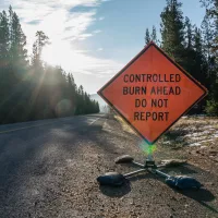
On Wednesday, Bend-Fort Rock Ranger District firefighters plan to conduct prescribed burn operations four miles west of Bend, south of the Cascade Lakes Welcome Station, adjacent to the east side of Forest Service 41 and west of the Deschutes River.
Firefighters plan to ignite up to 300 acres on the Big Eddy Prescribed Burn. Ignitions are planned for around 10 a.m. Smoke will be visible from Bend and the surrounding area. Residents in Bend and those south and east of the Deschutes River, including Sunriver, La Pine and Redmond are encouraged to keep doors and windows closed to minimize smoke impacts. Smoke impacts are most likely overnight and in the early morning hours.
The north bound lane of Forest Service Road 41 will be closed. A pilot car will be escorting traffic through the area. Drivers can anticipate a short delay.
The following closures will be in place during implementation and for up to a week following ignitions until firefighters assess conditions and determine the area is safe:
Deschutes River Access Points
- Lava Island Day Use River Access – Closed
- Big Eddy Day Use River Access – Closed
- Aspen Day Use River Access – Closed
Roads / Parking
- Forest Service Road 41 – The northbound lane of Forest Service Road 41 will be closed. Pilot cars will be escorting traffic through the area. Drivers can anticipate a short delay.
- All roads on the east side of Forest Service Road 41 between the junction with the Cascade Lakes Highway south to Dillon Falls – Closed
- Forest Service Road 41-800 (Access to Lava Island Day Use) – Closed
- Forest Service Road 41-750 (Access to Big Eddy Day Use) – Closed
- Forest Service Road 41-700 (Access to Aspen Day Use) – Closed
- Storm King Trailhead Parking – Closed
Trails
- Catch & Release – Closed between the Cascade Lakes Highway to Storm King junction.
- Deschutes River Trail – Closed from Meadow Day Use Area south to Dillon Falls. The Deschutes River Trail is open south of Dillon Falls.
- Deschutes River Horse Trail – Closed
- Deschutes River MTB Trail – Closed between Meadow Day Use Area south to Dillon Falls.
- One Hour Horse Trail – Closed
- Two Hour Horse Trail – Closed
The prescribed burn is within the West Bend Project area and received thinning and mowing to reduce vegetation loading prior to burning. Prescribed burning reintroduces and maintains fire within a fire-dependent ecosystem helping to stabilize and improve the resiliency of forest conditions while increasing public and firefighter safety. Once firefighters ignite prescribed burns, they patrol the units until they declare the burn out.
This prescribed burn is occurring within the Central Oregon Landscape, one of 21 focal landscapes identified within the Forest Service’s Wildfire Crisis Strategy. The implementation of this prescribed burn supports the Deschutes National Forest’s commitment to addressing the Wildfire Crisis Strategy which aims to reduce severity of wildfires, protect communities, and improve the health and resiliency of fire-dependent forests.
Prescribed burns can protect homes from tragic wildfires. Fire management officials work with Oregon Department of Forestry smoke specialists to plan prescribed burns. Prescribed burns are conducted when weather is most likely to move smoke up and away from our communities. While prescribed fire managers take significant preventive measures, it’s likely that communities may experience some smoke during or immediately after a prescribed burn.
What does this mean for you?
During prescribed burns, smoke may settle in low-lying areas overnight and in the early morning hours.
- All residents are encouraged to close doors and windows at night to avoid smoke impacts.
- If available, use a portable air cleaner. Air cleaners work best running with doors and windows closed. You can also create a DIY air cleaner.
- If you have a central air system, use it to filter air. Use high-efficiency filters if possible.
- When driving in smoky areas, drivers should slow down, turn on headlights and turn air to recirculating.
- If you have heart or lung disease, asthma, or other chronic conditions, pay attention to how you feel and if symptoms of heart or lung disease worsen, consider contacting your health care professional.
- Go to centraloregonfire.org to learn more about smoke safety and prescribed burning in Central Oregon and visit When Smoke is in the Air for more smoke preparedness resources.
For more information on prescribed burning in Central Oregon, visit centraloregonfire.org/ and for information specific to the Deschutes National Forest visit www.fs.usda.gov/deschutes. Follow us on X/Twitter @CentralORFire. Text “COFIRE” to 888-777 to receive wildfire and prescribed fire text alerts.