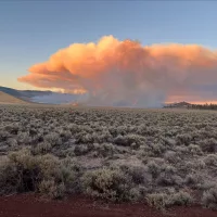
Firefighters continue suppression efforts on the Pine Fire located approximately 22 miles southeast of Bend, south of Highway 20 and south of Pine Mountain in the Kotzman Basin area.
The fire stayed within the established dozer line overnight. Firefighters will continue to secure lines around the perimeter of the fire by identifying and mopping up hotspots. The fire remains 6,537 acres and is 50% contained. This is a multiagency response with resources from federal, state and municipal agencies. Command of the fire will transition from a Type 3 organization to a Type 4 incident commander today.
Due to improved conditions and success by firefighters, the Deschutes County Sheriff’s Office is reducing evacuation levels around the Pine Fire.
Current evacuation levels are:
Level 3: Go Now! – Public lands on and immediately the eastern flanks of surrounding Pine Mountain including Antelope Ridge and private lands in Kotzman Basin (remains unchanged).
Level 2: Be Set – The western portion of Pine Mountain, south to FS Road 23 and south to Sand Springs and the Mahogany Butte Area.
Level 1: Be Ready – Areas north and east of Pine Mountain, south of Hwy 20 from FS Road 2017 (Pine Mountain Rd) to Fredericks Butte Rd.
People can stay up to date on current Deschutes County Sheriff’s Office evacuations at www.deschutes.org/emergency.
This will be the last daily written update unless significant changes occur.
Visit the official source for wildfire information in Central Oregon at centraloregonfire.org for wildfire updates or follow fire information on X/Twitter @CentralORfire. Call 9-1-1 to report a wildfire.