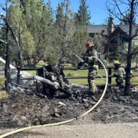
The Cram Fire burning on private land near mile post 76 on Highway 97 at Willowdale, and northeast Pony Butte Road. The fire is burning on private land protected by Willowdale Rangeland Fire Protection Association (RFPA) and is estimated to be 4,500 acres. The Cram Fire is 0% contained.
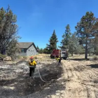
Prineville BLM Type 3 Incident Commander Aaron Roggenkamp is now in command of the Cram Fire. The fire burned actively while resources from both Willowdale and Ashland RFPAs joined BLM and Oregon Department of Forestry engines, crews and heavy equipment constructing fire line through the night. The plan for today will be to use the constructed lines and roads to directly and indirectly contain the fire, keeping it east of Highway 97 and south of Highway 293, then directly engage the fire on the south and east perimeters. Additionally, for the ranches and public infrastructure in and around the fire area, firefighters are doing structure protection work in advance of the fire, and then point protection when fire is near private property and public infrastructure. Additional resources have been ordered, including crews as well as air support from heavy air tankers and helicopters cooling hot spots.
The public is asked to heed all Oregon Department of Transportation signs and to slow down on Highway 97 because fire traffic is using those roads for active suppression efforts. Smoke can impact visibility on these roads so please drive slowly and with caution. Fire managers are also coordinating with Bonneville and Central Oregon Electric power companies who have lineman on scene or in the area in case of fire impacts.
Evacuations: Yesterday, the Jefferson County Sheriff’s Office issued Level 2 evacuation orders for NE 13, 15, 16 and the east part of NE 14, east of Hay Creek Road and all of those levels remain the same today. For more detailed information on Jefferson County evacuations, visit: https://tinyurl.com/JCSOEvacMap
The Highland Fire remains under the command of the Central Oregon Type 3 Incident Management Team, Crook County Fire and Rescue and the Oregon State Fire Marshal Blue Team and has now been more accurately mapped at 719 acres and is 5% contained. Information on that fire can be found on the Crook County Fire and Rescue Facebook page at: https://tinyurl.com/FacebookCCFR
Like today’s forecast calls for temperatures in the low 90s but variable winds across Central Oregon could bring gusts up to 30 miles per hour in some areas. This will likely make for challenging conditions for firefighting again today.
With continued hot and dry conditions, fire prevention is not just about protecting public lands, it is about the safety and security of our communities. Remember to follow all county, state and federal fire restrictions. If you are out recreating, don’t park over tall dry grass and ensure all spark arrestors for motorized equipment are in good working order. If you’re pulling a trailer, check that your trailer chains are properly secured off the ground. When you have a campfire, ensure you’re bringing enough water to fully extinguish it when you leave the area. Let’s all do our part to prevent one more spark.
Information on all fires in Central Oregon will be posted on the only official source for wildfire information in Central Oregon at centraloregonfire.org or on X/Twitter @CentralORfire.
Call 9-1-1 to report a wildfire. For smoke and air quality information visit fire.airnow.gov.