Due to more accurate fire mapping, the Highland Fire acreage was reduced to 719 acres with containment at 5% and is being managed by the Oregon Department of State Fire Marshal Blue Team and the Central Oregon Interagency Incident Management Team.
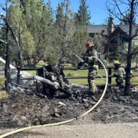
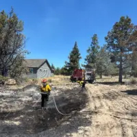
Crews built on the excellent work completed by local Crook County firefighters, strengthening fire line around the entire perimeter. Task forces conducted tactical patrols around homes and neighborhoods, and crews continued to search for hotspots in the duff while completing fuel reduction treatments, including tree limbing, juniper thinning, and hazard tree removal. Power was also restored to all residents in the Juniper Canyon area, thanks to Central Electric Cooperative.
Today, wildland firefighters will continue to secure the established perimeter of the fire, strengthening line 20’-30’ into the black. OSFM task forces will conduct structural assessments, mop up around structures, and maintain point protection in preparation for this afternoon’s weather.
The fire weather forecast is predicting temperatures in the 90s with late afternoon wind gusts of 20 miles per hour.
Evacuations: Evacuation levels issued by the Crook County Sheriff’s Office remain unchanged today. Approximately 1,500 people are under an evacuation notice related to Highland Fire activity. Residents can visit:
https://tinyurl.com/
There is a temporary evacuation shelter set up at Eastside Church at 3174 Northeast 3rd Street in Prineville. Rim Rock Riders have opened the arena at Brasada Ranch for large animals.
For more information on the Highland Fire, follow the Crook County Fire & Rescue Facebook page.