Overnight, firefighters continued to aggressively fight the 21,971-acre Flat Fire two miles northeast of Sisters, Oregon. Firefighters have been fighting the fire around the clock since Thursday afternoon.
Night shift crews were able to establish initial dozer and hand lines around portions of the fire. Notably, crews established initial lines along the southern head of the fire and made additional progress along portions of the north and west perimeter of the fire. Crews were also able to burnout unburnt vegetation in the Carcass Creek area to slow the fire’s spread.
Oregon State Fire Marshal (OSFM) firefighters remained engaged in residential areas throughout the south and southwestern portions of the fire, as well as Crooked River Ranch, suppressing fires around structures, extinguishing hot spots around homes and monitoring for embers.
“We were able to cut in some rough breaks around the fire to stop the spread around key areas and homes,” said Eric Perkins, Oregon Department of Forestry Complex Incident Management Team 3 Operations Section Chief. “We still have a lot of work ahead of us to improve lines and tie them together. We’re fighting this fire aggressively and safely, in cooperation with a lot of partners to saves homes in these communities.”
Sunday, firefighters will continue to face difficult terrain along with a red-flag warning today for hot conditions, combined with low relative humidities and an unstable air mass, with temperatures expected to reach triple digits. Ground crews will continue to work closely with air resources in an attempt to slow the fire’s forward progress, with a focus on protecting threatened structures.
OSFM structural task forces continue to focus efforts on homes in areas where the fire is most active. Type I strike teams have arrived and are dedicated to residential areas, reinforcing protection around homes and critical infrastructure. Where the fire front has passed, firefighters will be mopping up, extinguishing hot spots, and patrolling. “With the challenging weather conditions and changing winds, firefighter coordinated extremely well with all resources in the air and on the ground, defending homes and properties. The teamwork that is going on here is very streamlined.” Said Damon Schulze, Field Operations Chief for the Red Team.
Additional personnel and resources continue to arrive to increase capacity. All agencies continue to work closely with partner agencies to protect lives, property, and communities.
Community Meeting: Incident officials will host a community meeting at the Sisters High School, 1700 W McKinney Butte Rd., tomorrow, Monday, August 25, from 6:00–7:00 pm. Local and incident officials will provide a fire update and answer questions from the community.
To help fire operations and firefighter safety, the Bureau of Land Management and U.S. Forest Service ask that people stay out of the fire area. The BLM has implemented closures, which can be found under the Prineville tab on the following page: https://www.blm.gov/programs/public-safety-and-fire/fire-and-aviation/regional-info/oregon-washington/fire-restrictions.
As a reminder, drone use near fires is both illegal and extremely dangerous to pilots working on incidents. If you fly, we can’t. FAA Temporary Flight Restrictions are in place for the fire area. All illegal drone use will be reported to law enforcement.
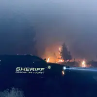
Level 1, 2 and 3 evacuations remain in effect under the direction of the Deschutes County Sheriff’s Office and the Jefferson County Sheriff’s Office. Follow their Facebook pages for the latest information and updates.
A 24-hour evacuation point has been setup at Highland Baptist Church located at: 3100 SW Highland Ave, Redmond, OR. Jefferson County Fairgrounds is available for large animals.
The Flat Fire started the afternoon of Thursday, August 21. A conflagration was declared on August 22, 2025.
The road closure update is for Sunday, August 24, not Saturday, as stated in the original news release.
The Deschutes County Sheriff’s Office is providing an update on road closures associated with the Flat Fire. Community members have been asking questions about access in the affected areas.
There are currently four primary road closures:
- Wilt Road is closed at Camp Polk Road
- Panoramic Drive is closed at Camp Polk Road
- Goodrich Road is closed north of Hwy 126
- Holmes Road is closed north of Fadjur Lane
For visual reference, a map has been created showing these closures. Yellow road signs on the map indicate closure points.
The map also highlights evacuation zones:
- Red – Level 3 (Go Now)
- Yellow – Level 2 (Be Set)
- Green – Level 1 (Be Ready)
We encourage residents to monitor official updates and remain aware of changing conditions.
Posted 12:24 p.m. 8/24/25:
Deschutes County Sheriff Ty Rupert and Lieutenant Nathan Garibay, with the Sheriff’s Office Emergency Management Unit, attended this morning’s Flat Fire briefing at the Sisters Rodeo grounds alongside state, regional, and local partners.
As of noon today:
- Nearly 4,000 homes remain in evacuation zones, with approximately 1,000 homes in Level 3 (Go Now).
- There are no changes to Deschutes County evacuation levels. The information shared last night remains current.
- Fire managers report that many homes have been saved, crediting the outstanding work of fire crews and the efforts of homeowners who created defensible space around their properties.
The Sheriff’s Office is working today to confirm the status of homes and structures impacted by the fire. Updates will be shared as soon as new information becomes available.
The Flat Fire Assistance Line is available daily from 8:00 a.m. to 8:00 p.m. at (541) 550-4888. Voicemails left outside these hours will be returned as soon as possible.
The American Red Cross has opened a shelter at Highland Baptist Church, 3100 SW Highland Avenue, Redmond. The shelter is open 24 hours a day and provides a safe place for overnight stays, daytime drop-ins, meals, and additional resources.
The Deschutes County Sheriff’s Office thanks the fire crews, partner agencies, and community members working tirelessly to protect lives and property.
Posted
Previous Post
Despite hot, dry and gusty conditions, fire crews continue to battle the 18,000-acre Flat Fire. Firefighters continue to face critical weather, steep terrain and shifting conditions. Ground crews continue to work closely with air resources in an attempt to slow the fire’s forward progress, with a focus on protecting threatened structures.
“Our firefighters are working under critical weather conditions and some very challenging terrain. We’re going to continue the aggressive firefighting that local resources and partners started,” said Aaron Whiteley Oregon Department of Forestry (ODF) Complex Incident Management Team (CIMT) 3 Incident Commander.
Oregon State Fire Marshal (OSFM) structural task forces continued providing point protection to properties and critical infrastructure threatened by the fire. Due to increased fire activity, OSFM crews focused efforts on structures impacted by the threat of the fire. This work includes active suppressing of fire around homes, creating a perimeter around homes, extinguishing hot spots around structures, controlling hot spots, and monitoring for embers.
“Public and firefighter safety are our primary concern,” said, Ian Yocum, Department of State Fire Marshal Red Team Incident Commander. “We’ll be in this firefight until structures are no longer in harm’s way.”
Additional personnel and resources continue to arrive and join day and night operational shifts and increase capacity. All agencies continue to work closely with partner agencies to protect lives, property, and communities.
These resources included two strike teams comprised of Type I engines. These large engines help bolster structural protection and allow more mobile resources to expand their efforts. Eight OSFM task forces will work tonight, ensuring protection remains in place around the clock.
ODF CIMT 3 assumed command of the Flat Fire from Central Oregon IMT 3 and unified with OSFM Incident Management Red Team at 6:00 p.m. this evening. To help fire operations and firefighter safety, The Bureau of Land Management and U.S. Forest Service ask that people stay out of the fire area.
As a reminder, drone use near fires is both illegal and extremely dangerous to pilots working on incidents. If you fly, we can’t. FAA Temporary Flight Restrictions are in place for the fire area. All illegal drone use will be reported to law enforcement.
***FLAT FIRE EVACUATION UPDATE: Saturday, August 23rd, 8:08 p.m.***
The major update is that Aspen Lakes Subdivision off Camp Polk Road has been elevated to a Level 3 (Go Now) Evacuation order, along with both sides of Edmundson Rd between Holmes Rd and Goodrich Rd
Here is the latest information from fire managers:
After consulting with local Fire Chiefs and incident commanders, the Deschutes County Sheriff’s Office has updated evacuation levels as the Flat Fire continues to grow and move. Based on the current and potential fire behavior today the following areas are now under Level 3 (GO NOW), Level 2 (GET SET), and Level 1 (BE READY) evacuation notices.
Large animals have been offered shelter at Kerley Horse Center, 11997 SW Cornett Loop, Powell Butte, OR 97753, 541-598-6358.
LEVEL 3 (GO NOW):
- Aspen Lakes Subdivision off of Camp Polk Road
- Both sides of Edmundson Rd between Holmes Rd and Goodrich Rd
- Between Wilt Rd MP 4 West to Stevens Canyon North to the County Line
- Whychus Canyon Estates south to Camp Polk Rd to
- Both sides of Wilt Road north to the Deschutes/Jefferson County line
- Areas North and West of Holmes Road, North of milepost 5 to Lower Bridge Rd
- All of McKenzie Canyon Rd
- Panoramic Estates off of Camp Polk Road
Level 3: Means “GO” evacuate now. Leave immediately! Danger to your area is current or imminent, and you should evacuation immediately. If you choose to ignore this advisement, you must understand that emergency services may not be available to assist you further. DO NOT delay leaving to gather any belongings or make efforts to protect your home. This will be the last notice you receive.
LEVEL 2 (GET SET)
- Area between Camp Polk rd, West along HWY 126 to include the Junipine Ln area and north to Old Military Rd
- Area North and East of Lower Bridge Rd to the Deschutes River
- Areas north of Hwy 126, including Goodrich Road, Holmes Roa,d and Fadjur Lane
Level 2: Means “BE SET” to evacuate. You must prepare to leave at a moment’s notice. This level indicates significant danger to your area, and residents should either voluntarily relocate to a shelter or with family and friends outside of the affected area, or if choosing to remain, be ready to evacuate at a moment’s notice. Residents MAY have time to gather necessary items, but doing so is at their own risk. This may be the only notice you receive. Emergency services cannot guarantee that they will be able to notify you if conditions rapidly deteriorate. Area media services will be asked to broadcast periodic updates.
LEVEL 1 (BE READY):
- Areas on the North side of East Indian Ford Road, from Wilt Rd to FS Rd 2050, including Stevens Canyon Road to MP 1.5, Fox Ridge Circle, and Pine Ridge Road.
- Dry Canyon area between Lower Bridge Rd, South to Hwy 126
- The area between Indian Ford Creek and Wychus Creek, north of Hwy 126 to the Camp Pollk Rd/Wilt Rd intersection, includes Indian Ford Ranch, Deer Ridge, Pine Ridge Loop, and McKinney Butte Subdivisions.
Level 1 Means “BE READY“ for potential evacuation. Residents should be aware of the danger in their area and monitor emergency services websites and local media outlets for information. This is the time for preparation and precautionary movements of persons with special needs, mobile property, and (under certain circumstances) pets and livestock. Emergency services personnel may contact you via an emergency notification system if conditions worsen.
A Temporary Evacuation Point at Highland Baptist Church is located at: 3100 SW Highland Ave, Redmond, OR.
Recreational Vehicle (RV) owners can park in the paved parking lot of the Deschutes County Fair and Expo Center through Tuesday, August 26.
Jefferson County Fairgrounds is available for large animals and support is being provided by the Pet Evacuation Team.
We will continue to work closely with fire managers and provide updates as the situation develops. Please follow official channels for accurate information.
Current maps, including evacuation areas, can be found at: https://deschutes.org/
For fire information, you can visit the Central Oregon Fire Information site at: www.centraloregonfire.org and follow the Flat Fire on Facebook.
Make sure you are registered for Deschutes Alerts to receive evacuation and emergency alerts and warnings in your area by going to www.deschutesalerts.org