Damage assessments from the Flat Fire, as of Sunday, August 24, have confirmed that several homes and outbuildings in Deschutes County have been lost or damaged, while hundreds more remain standing thanks to the work of firefighters and proactive property owners. The homes and structures affected are spread throughout the fire area.
So far, we know of the following impacts:
- Residential structures destroyed: 4
- Residential structures damaged: 1
- Other structures destroyed: 6
- Other structures damaged: 1
Residential structures include both primary and secondary residences. “Other structures” include shops, barns, garages, sheds, pump houses, and similar buildings. At this time, all known destroyed or damaged structures are located in Deschutes County.
As of 11:30 p.m. on August 23, 2025, there were 827 structures located within and immediately surrounding the fire perimeter. This remains an active incident, and the number of destroyed or damaged structures could change as additional assessments are completed.
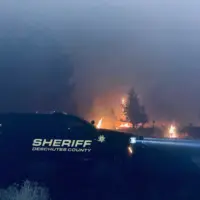
“We are deeply saddened by the loss of homes and personal property and extend our sympathy to those affected,” said Deschutes County Sheriff Ty Rupert. “We are also encouraged that hundreds of homes have been protected thanks to aggressive firefighting efforts and the proactive work of property owners to reduce fuels around their homes.”
Fire crews and emergency management personnel continue to assess the area and notify property owners when a damaged structure is identified. We will share updates if the numbers change.
There have been no new evacuation orders today. As of our update from Saturday evening, all areas under Level 1 (Be Ready), Level 2 (Be Set), and Level 3 (Go Now) remain unchanged.
Flat Fire Information & Resources:
- Current maps, including evacuation areas, can be found at: https://deschutes.org/
emergency
- For fire information, visit the Central Oregon Fire Information site at www.centraloregonfire.org and follow the Flat Fire on Facebook.
- Make sure you are registered for Deschutes Alerts to receive evacuation and emergency alerts and warnings in your area by going to www.deschutesalerts.org
- Flat Fire Facebook Page: https://www.facebook.com/
FlatFire
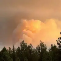
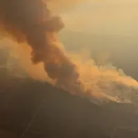
As of Sunday morning, the Flat Fire is estimated at 21,971 acres with 0% containment. The fire is burning approximately two miles northeast of Sisters, Oregon.
Daytime crews continued aggressive firefighting efforts amid difficult conditions today, as high temperatures and dry fuels resulted in increased fire activity. Crews worked under a Red Flag warning and heat advisory throughout the day. Despite the challenges, they were able to build on progress made overnight in the northeastern and southeastern portions of the fire.
In the northeastern portion of the fire, wildland resources reported reduced fire activity and were able to focus on strengthening and tying together portions of dozer line. On the southeastern portion of the fire, crews completed handline installation throughout Whychus Canyon.
The southern portion of the fire remained very active, and crews coordinated aggressive suppression efforts with air attack. Structural resources remained dedicated to structure protection and are actively engaged in firefighting efforts near homes. These crews are assigned to point protection, a tactic used to actively defend structures directly threatened by the fire. Point protection works in conjunction with coordinated efforts from wildland crews and air resources to slow the fire’s overall spread and impact.
On the western edge of the fire, challenging weather and terrain contributed to erratic fire behavior, resulting in a spot fire located off the northwestern corner of this morning’s fire perimeter. Resources that could be shifted from more stable portions were reassigned to this area, and crews will remain actively engaged with the spot fire.
The fire is expected to remain active late into the evening. As fire activity slows in the early morning hours, firefighters will take advantage of cooler temperatures and higher relative humidity to catch spot fires, reinforce line, and mop up hot spots. Seven OSFM Task Forces remain in place, providing structure protection through the night operational period.
Incident officials will host a community meeting tomorrow, Monday, August 25th, starting at 6:00 pm at the Sisters High School, located at 1700 W McKinney Butte Rd. Local and incident officials will provide a fire update and answer questions from the community. The meeting will be streamed virtually via the Sisters-Camp Sherman Fire Department Facebook page.
The Deschutes County Sheriff Office has provided a press release about the destroyed and damaged structures. The damage assessments will be an ongoing process while the fire is continuing to be active.
Evacuations:
Evacuations are managed by the Deschutes County Sheriff’s Office and the Jefferson County Sheriff’s Office.
Level 1, 2 and 3 evacuations remain in effect under the direction of the Deschutes County Sheriff’s Office and the Jefferson County Sheriff’s Office. Follow their Facebook pages for the latest information and updates. They can also be reached by phone: Deschutes County Sheriff’s Office at (541) 388-6655, and Jefferson County Sheriff’s Office (541) 475-6520.
A 24-hour evacuation shelter has been set up by the Red Cross at Highland Baptist Church located at: 3100 SW Highland Ave, Redmond, OR. Jefferson County Fairgrounds in Madras and Kerley Horse Center in Powell Butte are available for large animals.
Area closures: To help fire operations and firefighter safety, the Bureau of Land Management and U.S. Forest Service ask that people stay out of the fire area. The BLM has implemented closures, which can be found under the Prineville tab on the following page: https://www.blm.gov/programs/public-safety-and-fire/fire-and-aviation/regional-info/oregon-washington/fire-restrictions.
As a reminder, drone use near fires is both illegal and extremely dangerous to pilots working on incidents. If you fly, we can’t. FAA Temporary Flight Restrictions are in place for the fire area. All illegal drone use will be reported to law enforcement.
Local Road closures: The Deschutes County Sheriff is managing several local road closures.
- Wilt Road is closed at Camp Polk Road
- Panoramic Drive is closed at Camp Polk Road
- Goodrich Road closed north of Hwy 126
- Holmes Road closed north of Fadjur Lane
Smoke Report: Air quality continues to change. For current conditions, please visit: https://fire.airnow.gov/