(NEW YORK) — Freezing temperatures are hitting millions in the Midwest and Northeast on Thursday and Friday, bringing a brutal cold usually seen in January, not early December.
On Thursday morning, the wind chill — what the temperature feels like — plunged to minus 14 degrees in Minneapolis; minus 17 in Green Bay, Wisconsin; and minus 5 in Chicago.
When wind chills reach minus 20 degrees, frost bite can form on exposed skin within 30 minutes.
Daily record lows were broken Thursday morning, including in Waterloo, Iowa, which hit minus 10 degrees, and Aberdeen, South Dakota, which hit minus 18.
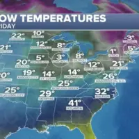
By Friday morning, the cold moves further east. Morning temperatures are forecast to hit 3 degrees in Chicago, 8 in Detroit, 12 in Pittsburgh and 21 in New York City. By Friday afternoon, wind chill conditions only warm up to 18 degrees in Chicago and 27 in New York.
Daily record low temperatures are possible Friday morning in cities in the Midwest and Northeast, including Chicago; South Bend, Indiana; Kalamazoo, Michigan; Columbus, Ohio; Pittsburgh; Manchester, New Hampshire; and Portland, Maine.
Meanwhile, residents of Tennessee, Virginia and North Carolina should brace for icy conditions on the roads.
Parts of Tennessee, including Nashville, could see snow or a wintry mix on Thursday evening.
On Friday, 1 to 2 inches of snow and a glaze of ice could cause slick roads in cities including Richmond and Roanoke, Virginia, and Greensboro, North Carolina.
Further west, the Texas Panhandle and Oklahoma are facing a wintry mix of snow and sleet on Thursday morning, potentially leading to icy driving conditions.
Copyright © 2025, ABC Audio. All rights reserved.