A Winter Storm Warning is in effect from 4:00 a.m. Tuesday, 1/6/26, to 4:00 p.m. Thursday 1/8/26. Heavy snow possible in the Upper and Lower Slopes of the Eastern Washington Cascades Crest, Northern Blue Mountains of Oregon, East Slopes of the Oregon Cascades, and Northwest Blue Mountains. Total snow accumulations between 20 and 30 inches possible.
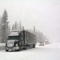
Heavy snowfall and very low visibility will create extremely dangerous driving conditions. Gusty winds could bring down tree branches.
Total snow accumulations of 24-30 inches for Washington Cascades, 17-25 inches for Oregon Cascades, and 10-20 inches for the Northwest Blue Mountains will be possible.
Heaviest snow expected Tuesday morning through Tuesday Evening.
Persons should consider delaying all travel. If travel is absolutely necessary, drive with extreme caution. Consider taking a winter storm kit along with you, including such items as tire chains, booster cables, flashlight, shovel, blankets and extra clothing. Also take water, a first aid kit, and anything else that would help you survive in case you become stranded. Do not touch downed lines and report any power outages to your electric company. Travel is highly discouraged due to slick roadways and the possibility of downed trees and power lines.
Source: U.S. National Weather Service