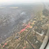
The Flat Fire, burning approximately two miles northeast of Sisters, Oregon, is estimated at 23,261 acres after updated infrared (IR) mapping and is 7% contained.
Overnight, firefighters expanded upon progress made during the day. Crews improved the established dozer and hand line; extended hose installations; and expanded mop-up inside the fire perimeter. Infrared (IR) was utilized by structural and wildland resources to identify and extinguish hidden hot spots near homes and around the fire perimeter.
Firefighters have been working around the clock to secure lines and prepare for hotter, drier, and windier conditions. Crews have made steady progress, strengthening established line, mopping up heat near structures, and completing miles of handline and dozer line. That work has put firefighters in a stronger position going into a period of critical fire weather. However, much remains to be done.
Warm weather, thunderstorms, and erratic winds will begin to test lines today. Gusts from the north and northwest are expected to challenge the eastern and southeastern fire line starting tomorrow.
On the eastern perimeter of the fire, foot patrols between the Flat Fire and Alder Springs burn scar continue to improve areas of line. The Lower Bridge Rangeland Fire Protection Association (RFPA) will help bolster resources along the eastern edge. RFPAs are volunteer organizations of local landowners trained to fight wildfires in rangeland areas. Structural crews will be working near Goodrich Road, extinguishing hot spots where winds have stirred up smoldering embers around homes.
On the southeastern perimeter, wildland crews continue working to complete hose lays ahead of wind that will challenge area lines. On the southwestern edge, structural and wildland resources are coordinating efforts to shore up protection of homes along the canyon rim. Along the western perimeter, crews have progressed to mopping up 150 feet inside the fire and are addressing overhead hazards caused by fire-damaged trees. Air support is available and is being utilized when needed, as weather allows.
Evacuations:
Evacuations are managed by the Deschutes County Sheriff’s Office and the Jefferson County Sheriff’s Office.
Level 1, 2, and 3 evacuations remain in effect under the direction of the Deschutes County Sheriff’s Office and the Jefferson County Sheriff’s Office. Follow their Facebook pages for the latest information and updates. They can also be reached by phone: Deschutes County Sheriff’s Office at (541) 388-6655, and Jefferson County Sheriff’s Office (541) 475-6520.
A 24-hour evacuation shelter has been set up by the Red Cross at Highland Baptist Church located at: 3100 SW Highland Ave, Redmond, OR. Jefferson County Fairgrounds in Madras and Kerley Horse Center in Powell Butte are available for large animals.
Local Area closures: To help fire operations and firefighter safety, the Bureau of Land Management and U.S. Forest Service ask that people stay out of the fire area.
The BLM has implemented closures, which can be found under the Prineville tab on the following page: https://www.blm.gov/programs/public-safety-and-fire/fire-and-aviation/regional-info/oregon-washington/fire-restrictions.
The U.S. Forest Service has implemented closures, which can be found on the following page: https://www.fs.usda.gov/r06/deschutes/alerts
As a reminder, drone use near fires is both illegal and extremely dangerous to pilots working on incidents. If you fly, we can’t. FAA Temporary Flight Restrictions are in place for the fire area. All illegal drone use will be reported to law enforcement.
Local Road closures: The Deschutes County Sheriff is managing several local road closures.
- Wilt Road is closed at Camp Polk Road
- Panoramic Drive is closed at Camp Polk Road
- Goodrich Road closed north of Hwy 126
- Holmes Road closed north of Fadjur Lane
Smoke Report: The current smoke outlook for Central Oregon can be found on the following page: https://outlooks.wildlandfiresmoke.net/outlook/6436a95d
The Flat Fire is estimated at 23,261 acres after updated infrared (IR) mapping – with 7% containment. The fire is burning approximately two miles northeast of Sisters, Oregon.
Firefighters took advantage of cooler morning temperatures Tuesday to gain ground on mop-up operations throughout the fire – even reaching 100-200 feet inside the fire, along the eastern and western perimeters. The southern end of the fire has remained the most active, and resources have shifted from other divisions to aid in the labor-intensive work needed there. Within the fire perimeter, wildland firefighters are addressing complex, patchy burn areas where fuel loads remain.
Structural resources are actively engaged with extinguishment around homes, as warm, shifting afternoon winds stir up hot spots. Fallers, specialized personnel who remove dangerous, fire-weakened trees, are working to ensure structural crews can access homes and continue mop-up operations around structures.
Overnight, crews will capitalized on cooler, more stable conditions to focus on the crucial task of securing lines ahead of the increased temperatures, winds, and decreased relative humidity expected later this week. This combination of conditions, known as critical fire weather, increases the risk for fuels to ignite, as well as the potential for torching and spotting. Firefighters are working tirelessly to complete this work ahead of the predicted weather shift.
Evacuations:
Evacuations are managed by the Deschutes County Sheriff’s Office and the Jefferson County Sheriff’s Office.
Level 1, 2, and 3 evacuations remain in effect under the direction of the Deschutes County Sheriff’s Office and the Jefferson County Sheriff’s Office. Follow their Facebook pages for the latest information and updates. They can also be reached by phone: Deschutes County Sheriff’s Office at (541) 388-6655, and Jefferson County Sheriff’s Office (541) 475-6520.
A 24-hour evacuation shelter has been set up by the Red Cross at Highland Baptist Church located at: 3100 SW Highland Ave, Redmond, OR. Jefferson County Fairgrounds in Madras and Kerley Horse Center in Powell Butte are available for large animals.
Local Area closures: To help fire operations and firefighter safety, the Bureau of Land Management and U.S. Forest Service ask that people stay out of the fire area.
The BLM has implemented closures, which can be found under the Prineville tab on the following page: https://www.blm.gov/programs/public-safety-and-fire/fire-and-aviation/regional-info/oregon-washington/fire-restrictions.
As a reminder, drone use near fires is both illegal and extremely dangerous to pilots working on incidents. If you fly, we can’t. FAA Temporary Flight Restrictions are in place for the fire area. All illegal drone use will be reported to law enforcement.
Local Road closures: The Deschutes County Sheriff is managing several local road closures.
- Wilt Road is closed at Camp Polk Road
- Panoramic Drive is closed at Camp Polk Road
- Goodrich Road closed north of Hwy 126
- Holmes Road closed north of Fadjur Lane
Smoke Report: The current smoke outlook for Central Oregon can be found on the following page: https://outlooks.wildlandfiresmoke.net/outlook/6436a95d