This update replaces the February 3, 2026 release regarding prescribed fire operations on the Crooked River National Grassland.
Planned pile burning scheduled for Wednesday, February 4 has been postponed due to unfavorable weather conditions. Fire managers will continue to monitor conditions and are evaluating potential opportunities to conduct pile burning next week, pending favorable weather and required approvals.
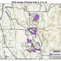
The prescribed pile burning was planned for approximately 70 acres within the Crooked River National Grassland, located approximatly four miles southeast of Madras in the vicinity of Buck Butte and east of Highway 26. No burning will occur today.
Prescribed fire operations are only conducted when weather, fuel moisture, and air quality conditions align to ensure public and firefighter safety and to meet project objectives. Weather conditions are evaluated immediately prior to ignition, and scheduled activities may be postponed or canceled when conditions are not suitable.
For more information on prescribed burning in Central Oregon, visit centraloregonfire.org/ and for information specific to the Ochoco National Forest visit fs.usda.gov/r06/ochoco. Follow us on X/Twitter @CentralORFire. Text “COFIRE” to 888-777 to receive wildfire and prescribed fire text alerts.
previous release:
Crooked River National Grassland and Ochoco National Forest are planning prescribed fire operations this Wednesday, February 04 around 10:00 a.m., pending all required approvals.
Prescribed fires planned for the area include:
- Approximately 70 acres within the Crooked River National Grassland
- An area located approximately 4 miles southeast of Madras, in the vicinity of Buck Butte and east of Highway 26
Prescribed burning will be managed by Forest Service resources from the Ochoco National Forest. Forest Service personnel will be on scene throughout the operation to ensure safe and effective implementation.
Smoke may be visible from Prineville, Terrebonne, and Madras. Smoke impacts are anticipated along Southeast Grizzly Road and the Highway 26 corridor, particularly overnight and in the early morning hours as air settles into low-lying areas.
Prescribed burn warning signs will be placed along Grizzly Road and Highway 26. Drivers should slow down and use headlights if visibility is reduced.
Prescribed burning will only occur when weather, fuel moisture, and air quality conditions meet criteria for safe and effective operations. If conditions are not suitable, ignitions will be postponed.
Weather conditions will be evaluated in the hours before a burn begins. If conditions warrant, scheduled prescribed fire activities may be canceled.
Residents may experience smoke during the prescribed burns. For more detailed information about air quality, go to AirNow online or download the app. When driving, slow down and turn on your headlights when you encounter smoke on the road. For more information on prescribed burning in Central Oregon, visit centraloregonfire.org/ and for information specific to the Ochoco National Forest visit fs.usda.gov/r06/ochoco. Follow us on X/Twitter @CentralORFire. Text “COFIRE” to 888-777 to receive wildfire and prescribed fire text alerts.
About the Forest Service: The USDA Forest Service has for more than 100 years brought people and communities together to answer the call of conservation. Grounded in world-class science and technology– and rooted in communities–the Forest Service connects people to nature and to each other. The Forest Service cares for shared natural resources in ways that promote lasting economic, ecological, and social vitality. The agency manages 193 million acres of public land, provides assistance to state and private landowners, maintains the largest wildland fire and forestry research organizations in the world. The Forest Service also has either a direct or indirect role in stewardship of about 900 million forested acres within the U.S., of which over 130 million acres are urban forests where most Americans live.